Rouge Valley Conservation Centre
Rouge Valley Conservation Centre Deer Count
2017 Deer Census and Mammal Count
Rouge River Valley – Central Woodland Complex to Steeles Avenue
February 25, 2017
Paul Harpley
The Annual Rouge Valley Deer Census took place on February 25 beginning with the pre-census strategy meeting at the Rouge Valley Conservation Centre respecting current weather, snow and related tracking conditions, schedule for the day, and health & safety considerations. The tracker participants (15) included naturalists from the local Rouge area and other communities in and around the City of Toronto, York and Durham Regions. Most participants were experienced trackers (group leaders) while others were naturalists of varying expertise. The Rouge Valley Deer Census has become well known over the years for its unique naturalist experience, consistent records and valuable deer and deer signs observations. The area of the survey is generally bounded in the south by Twyn Rivers Road, on the east by the Toronto-Pickering Townline, north by Steeles Avenue, and west by Meadowvale Road, Old Finch Avenue and Sewells Road. This is a large, relatively continuous wilderness-like near urban representative deer range habitat area, with rural/human cultural affinities in the Rouge River watershed.
The day started out mostly overcast at 9:00 a.m. with temperature 0 degrees Celcius and moderate wind conditions increasing slightly throughout the day. The temperature had risen to +5 degrees Celsius by midday. The sun appeared intermittently in the afternoon after 3:00 p.m. and overall the sky remained 75% cloudy for the day. Participants started the count with a walking surface of intermittent soft no recent snow and uncharacteristically with almost no snow on the walking surface, In a few sheltered and shaded areas of the forests some old hard-packed drifts were persisting (less than 5% of the census ground surface. Until this year, and for the last 10 years (except 2015 and 2014 where almost no areas had absence of snow on the ground) the snow cover was present enough to exhibit deer tracks well. The lack of snow was thought to be problematic, however as it turned out there was little ice and most trails were moderately muddy, so that deer tracks showed consistently and well for the Count. This winter had been unusually warm and very cold at times, having numerous thaws, and regular moderate snow storm events throughout, making it very variable and unpredictable with regard to weather prediction. Optical conditions were good on Census day.
As in past years, deer were surveyed by signs (and estimated as to number) and by actual observation of individual deer seen. Signs observed and recorded ranged from tracks, trails, scat (pellet groups), beds, buck rubs, browse evidence, urine spots, kills (dead deer or parts – coyote, car or railway caused), corn and other agricultural browse evidence, to pseudo winter yarding areas (not full yards like in central/northern Ontario). Final Census day data was reviewed by tracker participants and evaluated by each major geographic survey zone in the study area. A final mediated estimate of overall deer numbers for the census study area was determined by those in the field that day. The past established wildlife management count methodology was followed, and informed by current field knowledge of contemporary local conditions, previous other seasonal observations, and past experience of the organizers and experienced tracker participants.
The Census ended by 4:30 p.m. Some key management comments can be made. As in 2013 to 2016 there was little evidence of deer hunting (poaching) in the area (within the boundaries of the City of Toronto) in contrast to some past recent years. No recent existing hunter/deer stands were observed or documented though a couple of old locations were noted. Coyote (Brush wolf) tracks were seen on survey day, and a couple of individual animals observed. A couple of areas were noted as hot spots for coyote (sign and observed animals) at the time of the count, similar in location to past years. Consistent with historical recent data, much of the deer activity was observed in the north-central zones of the census area of the survey in 2014-2016. Moderate deer browse of a few recent planting sites was noted in the survey area as in past surveys. Corn fields, Staghorn sumac and Eastern white cedar were preferred deer browse, as has been typical over the many years of the Count. However, it was specifically noted that upland areas in the large open field and forest edges dogwood and Canadian hemlock were particularly heavily browsed compared to previous years.
There were a number of buck rubs reported higher than the consistent number with past surveys. This led to conversation and discussion following the survey considering that more buck groups may be using the Rouge Park area than in past years as autumn/winter refuge than in past years. No definitive statement can be made but future years’ surveys will investigate this. Observed and documented pellet group scats, major deer congregation areas, and established deer trails north/south were higher in most survey areas than in 2016. As in 2017 some traditional deer areas in winter were being used as walking trails regularly by people (and dogs not on leashes), and in some of these, deer have started to move out of those areas (for example old Woodland Park, the Meadowvale east yard, and the Beare Road Landfill) similar to observations in 2012 through 2016. As previously reported in other years some future refinement to human use trails (especially with dogs) in these areas may lessen human impact on deer in the study area. Dog walkers were perceived as the most probable cause of the documented movements of deer out of southern, more accessible trail areas. Concern continues to be noted about deer being pushed out of high use areas over future years by continued trail development and homogenized human centric habitat of established trail areas over time. In general all deer observed looked to be in good health. No deer antlers were reported found by tracker surveyors.
In total, 85 - 95 White-tailed deer were estimated to be in the count area on the survey day (observed and inferred by signs) about 10 percent higher than numbers 2012 to 2016, and with fifty (50) individual deer actually seen by all participants (mainly adult does and yearlings) during the census this represents a considerably higher observation incidence than typical (including 2016), within the last ten years. A large group of 16 deer was seen in one location. One dead deer location was found, with skeletal bones in the area including a skull that had recent evidence of coyote (Brush wolf) in the location. Blood and bones with meat and fur were strewn around the forest edge/field area.
The area deer estimate was considered relatively accurate and consistent with numbers for most of the past years, though the lack of ground snow made overall estimates more speculative than in some of these years. The general habitat observation in the study area having fewer recently planted restoration trees (susceptible to deer browse) is considered by some regular surveyors as a possible reason for continuing lower overall deer numbers since 2000, and in the late 1990’s, as planting trees are maturing above easy deer browse height. In general the harshness of the winter
weather and consistent deep snow in some winters, are limiting factors for W.T. deer in Ontario, undoubtedly keeping deer winter numbers down here as anywhere and the observed mild winter in 2016 may have positively affected survivorship slightly into 2017, as is anecdotally apparent in the current survey. Due to the absence of snow this year evidence of deer night beds documented on the count this year were potentially lower from the previous censuses but the fact that a high number were found is consistent with feeling that deer numbers were higher this year.
As in past recent years, other mammals were observed and documented, as were birds and other fauna. In total there were 11 mammal species observed including White-tailed deer, Coyote, Red fox, Gray squirrel, Red squirrel, Cottontail rabbit, Raccoon, Striped Skunk, Short-tailed shrew, White-footed mouse, and American beaver signs. Avian animals seen this winter included 12 expected species documented, notables being Red-tailed hawk, Pileated woodpecker and a group of 25 Tundra swans (unexpected) flying overhead around seen by a couple of survey groups around 2:00 p.m.
Many thanks to those who contributed to the census.
Paul Harpley B.Sc. (Hons.) M.A.


To donate to the Rouge Valley Conservation Centre click on the button below:
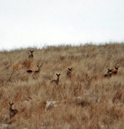
White-tailed deer in the Rouge River Valley. Photo by Bill Lewis.
(this photo was not taken during the Deer Count)
Kids Programs
Special Events
Donate
About Us
Rouge Valley Conservation Centre © 1995 – 2018 All rights reserved